The WGM (World Gravity Map) is a project of the Commission for the Geological Map of the World (CGMW), UNESCO, International Union of Geodesy and Geophysics (IUGG) and International Union of Geological Sciences (IUGS) to map the Earth's gravity anomalies.
This project was led by the International Gravimetric Bureau (IGB), a service of the International Association of Geodesy that remains in France and supported by several establishments involved in the gravity measurement application (CNES, IRD, INSU, IGN, BRGM, IFREMER, SHOM, Observatory of Midi-Pyrénées in Toulouse, IPG of Paris, EOST of Strasbourg, the Geosciences laboratory of Montpelier, ESGT of Le Mans).


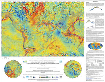
The three maps set above shows the first global maps of gravimetric anomalies calculated in spherical symmetry, taking into account a realistic model of Earth.
The gravity anomalies presented here (Bouguer, Fresh air and Isostatic) integrate observations resulting from gravimetric ground, offshore and satellite measurements (CHAMP, GRACE, GOCE) and take into account high resolution topographic corrections (including the mass effect due to the continents, oceans, lakes, inland seas and polar icecaps). These maps are generally locally edited so new theoretical developments were necessary to make the world calculation possible.
Such anomaly maps featuring the density differences inside the globe (crust, mantle, etc.), have many applications in Earth physics, structural geology (Earth's shape, geoid), geodesy as well as natural resource seeking (mining and oil explorations). Available through maps or numerical grids, they are planned to be regularly updated and published for research and education purposes.
The numerical files (maps and grids) will be subsequently uploaded on the website of the BGI which is also going to propose updated versions featuring the GOCE new models as well as other surface data (update of the anomaly grids). More actions are being considered in order to take advantage of these products like automatic extraction and generation of maps and local correction grids, global anomaly review via Google Earth, DVD including multilingual notices, etc.
Article references
Balmino, G., Vales, N., Bonvalot, S. and Briais, A., (2011), Spherical harmonic modeling to ultra-high degree of Bouguer and isostatic anomalies. Journal of Geodesy. DOI 10.1007/s00190-011-0533-4).
Contacts
- Scientifif contact: Sylvain Bonvalot of Geosciences Environnement Toulouse
- CNES solid Earth program scientist: Mioara Mandea