
The VEGETATION-1 instrument on board SPOT-4 and then VEGETATION-2 on board SPOT-5 were respectively launched in 1998 and 2002 to ensure a daily monitoring of the continental vegetation. The outstanding 1-km resolution image series which has been being filled up for 12 years contains valuable information on the state and evolution of the terrrestrial surfaces.
The national and international science community exploits these data in order to monitor the state of the biosphere and assess the impact of the disruptions experienced by the continental ecosystems.
Among the major results, the 1-km resolution global land-use map was realised within the frame of the GLC2000 (Global Land Cover) project and the temporal series (1999-2007) of biophysical parameters of the CYCLOPES project.
VEGETATION's data, supplied by the VEGETATION image Processing Centre (CTIV) of VITO (Belgium), are also crucial entries for operational services such as the MARS (Monitoring Agricultural ResourceS) programme implemented by the European Commission in the Joint Research Centre (JRC).
Geoland2 monitors the continental surfaces
Since 2008, the geoland2 project of the European Union 7th Framework Research and Development Programme has been aimed to implement the "Land" service of the GMES' (Global Monitoring for Environment and Security) programme. One of the geoland2's components - the Core Mapping Service BioPar - is dedicated to reproduce the biophysical properties of the continental surfaces on a global scale. Within this frame, the VEGETATION data are exploited in order to estimate physical quantities such as the Leaf Area Index (LAI), plant cover, albedo and calculate the normalized difference vegetation index (NDVI).
The INRA of Avignon defined an original methodology which was enhanced by the previous results of the CYCLOPES project. CNES did industrialize the algorithm, make the processing chain reliable and robust and process the 12 years of VEGETATION images available to produce a decadal map of these parameters.
The software, transferred and installed in the operational production centre of VITO, keeps systematically producing these maps in less than three days after the collection of the last image of the decade. These current and past SPOT/VEGETATION products just like all the data resulting from the geoland2 project are freely available for the whole science community through a single web portal.
This SPOT/VEGETATION series of biophysical parameters of the vegetation will be completed in the near future by the data gathered since 1982 by the successive NOAA/AVHRR instruments with the same methodology. A single view of the global ecosystem will thus be available in order to show the 30-year evolution either resulting from natural changes or demographic pressures.
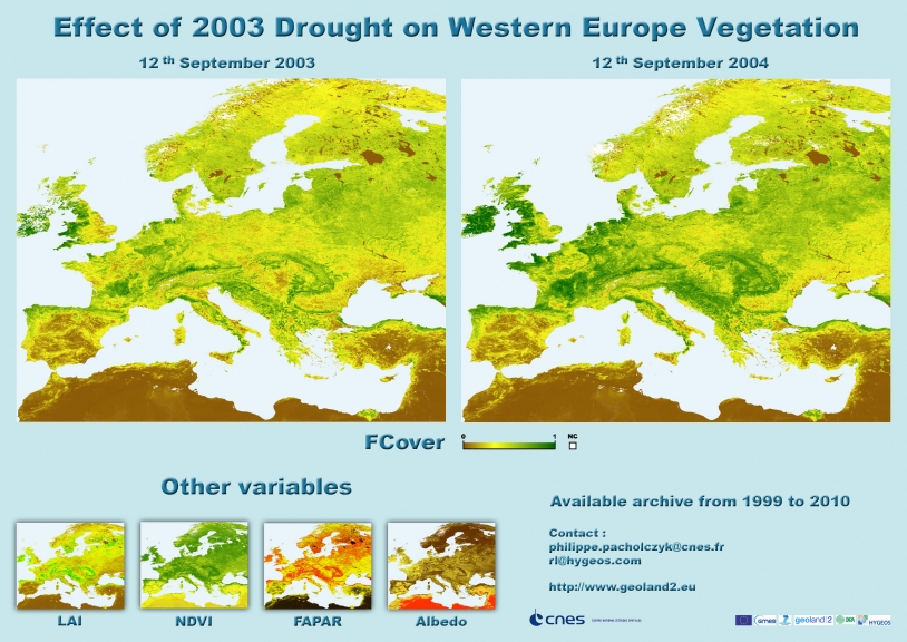
For example, the maps below show the effect of the 2003 drought in Western Europe: the green vegetation rate is sensitively lower than that of a normal year such as 2004. By comparing the past data to the current SPOT/VEGETATION results, it is possible to detect the anomalies and assess their extent and consequences for applications such as natural resource management (water, forest, etc.) and crop yield forecasting.
The assimilation of the current biophysical products within the soil-vegetation-atmosphere transfer models allows the meteorological forecasts and carbon budget estimates to be refined. These applications are at the very heart of the GMES' "Land" service. Its continuity is going to be ensured by adapting the current methodologies to the instruments' specifications of the PROBA-V, Sentinelle-2 and Sentinelle-3 missions which are planned to succeed SPOT/VEGETATION.
Contacts
- Scientific contacts : Roselyne Lacaze (HYGEOS), Philippe Pacholczyk (CNES, DCT/ME/OT)
- CNES Continental Surfaces program scientist: Selma Cherchali
